

Photo Record
Images
Metadata
Title |
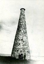
Stage Island navigation marker |
Catalog Number |
0707 |
Object Name |
Print, Photographic |
Description |
Navigation marker on Stage Island, circa 1900. Stage Island gets its name from its early use by fishermen to dry fish for export to Spain and the West Indies. The fish were spread to dry on wooden racks called stages. This stone tower, about 60 ft. high, was built by the U.S. government in 1825 to mark the deep water passage for sailors into Biddeford Pool. During the building of the tower, a faulty foundation caused the stones to collapse and one of the contractors was killed and several men injured. The tower was promptly rebuilt and has stood without accident since. It is 20 feet wide at teh base and teh walls are 4 feet thick. |
Date |
1900 |
Photographer |
Unknown |
Collection |
IMAGES |
Provenance |
FIC |
Place |
Biddeford (Me.) |
Neg Loc |
Annex--Condensed Shelving--Rear |
Neg # |
707 |
Orig/copy |
Original |
Print size |
5" x 7" |
Film Size |
5 x 7 film |
Search Terms |
Biddeford Biddeford Pool Stage Island Saco Bay |
Relation |
Show Related Records... |